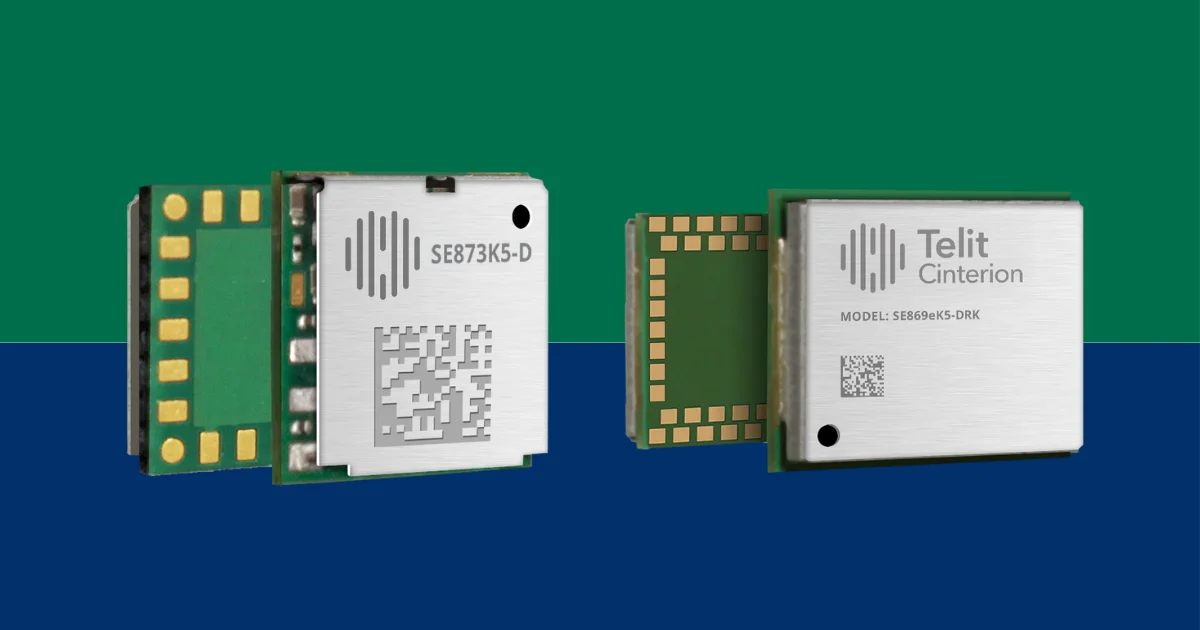
 Positioning receivers often behave perfectly during early development. Clear sky, strong satellite visibility, predictable movement. The coordinates look stable on the screen and everything appears under control. Then the device leaves the lab. Signals begin reflecting from nearby structures, satellite visibility changes between streets, and position estimates start drifting in ways that are frustratingly inconsistent. Engineers building asset trackers or drones run into this sooner or later. Telit Cinterion’s new SE873K5-D GNSS module is aimed squarely at this problem, bringing dual-band satellite reception into hardware that barely occupies board space.
At the opposite end of the positioning spectrum sits the SE869eK5-DRK, a GNSS module designed for applications where location data cannot simply disappear when satellite signals fade. The SE869eK5-DRK is a GNSS positioning module used for navigation systems that require continuous location tracking even when satellite reception is interrupted. Instead of relying solely on satellite fixes, the device combines GNSS positioning with inertial sensing so the system can continue estimating motion when reception is interrupted. It is a different approach to the same reality engineers face once devices leave controlled test environments.
Dual-Band GNSS Inside The SE873K5-D Module
Many IoT designs still rely on single-frequency GNSS receivers operating on the L1 band. They are simple, well understood, and relatively efficient from a power perspective. The weakness only becomes obvious once the device moves into dense urban areas or environments with reflective surfaces. Multipath signals distort timing measurements and the receiver begins producing position fixes that look correct but gradually wander.
The SE873K5-D tackles that issue by observing both the L1 and L5 GNSS bands. Having two frequency measurements allows the receiver to better identify distorted signals and reduce certain multipath errors. Accuracy does not magically become perfect. Urban environments remain complicated. But dual-band receivers tend to behave more predictably when signals become messy.
What makes the module particularly interesting is the size. The device maintains the same 7 × 7 mm footprint used by the earlier SE873K5 single-frequency design. From a board layout perspective this matters a lot. RF sections are often the most constrained areas of a design, and pin compatibility means engineers can upgrade positioning capability without reworking the surrounding circuitry.
In small asset trackers the GNSS module often shares board space with the cellular modem and battery charger, leaving very little room for antenna isolation or RF filtering. Designs like this are exactly where compact dual-band receivers become valuable. The module also supports multi-constellation GNSS reception and can apply differential corrections using RTCM data streams. In practice that allows position accuracy to tighten significantly compared to standalone GNSS fixes, which becomes noticeable in tracking or drone navigation systems.
SE869eK5-DRK Adds RTK Positioning And Inertial Navigation
While the smaller module focuses on compact IoT devices, the SE869eK5-DRK is built for systems that cannot tolerate losing position when GNSS signals disappear. Anyone working on vehicle navigation quickly learns how often this happens. Tunnels, underground structures, dense city streets. Satellite visibility can vanish for longer than expected.
The module addresses this by combining multiple positioning techniques. Real-time kinematic correction allows the receiver to reach centimeter-level accuracy when correction data is available. When signals degrade or drop entirely, an integrated inertial measurement unit continues estimating motion through dead reckoning.
In a typical fleet tracking system the GNSS receiver produces location fixes every few seconds while a cellular modem pushes position updates to cloud services. Interruptions in satellite visibility can disrupt that data stream, which is why combining GNSS with inertial sensing has become increasingly common in higher-end navigation hardware. Dead reckoning always accumulates error eventually. But for many navigation systems it provides enough continuity to bridge temporary signal loss. When satellite reception returns, the receiver can realign its position estimate using the GNSS fix.
The SE869eK5-DRK uses a larger 16 × 12.2 mm package that exposes additional interface signals. Telit introduced an extended pinout here while keeping the module compatible with earlier designs. That allows existing systems to adopt the updated module without completely redesigning their hardware.
GNSS Modules Are Quietly Becoming More Complex
One detail that stands out across both modules is how much positioning technology now fits inside what still looks like a small RF component. The devices are built around Airoha’s AG3335 chipset family and support multiple satellite constellations, correction services, and in the case of the higher-end module, inertial sensing as well.
A few years ago many embedded GNSS receivers were essentially satellite timing engines. They produced coordinates and left the rest of the system to deal with accuracy limitations. Today the positioning subsystem is evolving into something closer to a navigation engine, blending satellite signals with correction services and motion sensors.
From the outside the modules still appear small and simple on a schematic. The positioning system hiding inside them is becoming much more sophisticated.
Learn more and read the original announcement at www.telit.com
Technology Overview
The SE873K5-D and SE869eK5-DRK are GNSS positioning modules from Telit Cinterion designed for IoT devices requiring reliable satellite-based location tracking. The SE873K5-D provides dual-band L1 and L5 GNSS reception in a 7 × 7 mm footprint, while the SE869eK5-DRK adds RTK positioning and dead reckoning using an integrated inertial measurement unit.
Frequently Asked Questions
What are the Telit SE873K5-D and SE869eK5-DRK used for?
They are GNSS positioning modules used in IoT devices such as asset trackers, drones, fleet management systems, and navigation equipment requiring accurate satellite positioning.
What GNSS capabilities do the SE873K5-D and SE869eK5-DRK support?
The modules support multi-constellation GNSS with dual-band L1 and L5 reception, with the SE869eK5-DRK also supporting RTK positioning and dead reckoning using an integrated IMU.
You may also like